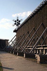
Tag:man_made=graduation_tower
Jump to navigation
Jump to search
| Description |
|---|
| Graduation tower. |
| Group: man made |
| Used on these elements |
| Useful combination |
| Status: de facto |
| Tools for this tag |
|
The tag man_made=graduation_tower describes ![]() graduation towers (structures used in the production of salt which removes water from a saline solution by evaporation, increasing its concentration of mineral salts).
graduation towers (structures used in the production of salt which removes water from a saline solution by evaporation, increasing its concentration of mineral salts).
Often constructed due to supposed health benefits and placed in parks (the mineral-rich water droplets in the air are regarded as having beneficial health effects similar to that of breathing in sea air).
How to map
Draw tag man_made=graduation_tower as a node or area.
Related tags
| Key + Tag | Description | Recommendation |
|---|---|---|
man_made=graduation_tower
|
Main tag. | ! Required |
operator=*
|
Operator of graduation tower. | ‽ Important |
opening_hours=*
|
The opening hours of graduation towers. | ‽ Important |
brine_source=*
|
The origin of the brine in the graduation tower. (the place where the brine is extracted) | ? Optional |
building=yes |
If the graduation tower is a building. | ? Optional |
tourism=attraction
|
If the graduation tower is an attraction. | ? Optional |
length=*; height=* & width=*
|
Dimensions of the graduation tower. | ? Optional |
lit=yes
|
If the graduation tower is lit. | ? Optional |
fee=yes
|
If you have to pay to use the graduation tower. | ? Optional |
seasonal=yes
|
If the graduation tower does not work in winter. | ? Optional |
start_date=*
|
If the date of the opening is known. | ? Optional |
Examples
| Image | 
|

|
|---|---|---|
| Tagging |
|
|
Rendering
No rendering yet.
